|
|
|
ESMS Maps allows users to relate system objects (points, devices, views, etc) to GPS or custom coordinate systems on graphical backgrounds called maps.
Maps displayed on the ECS station utilize geospatial coordinates for location of objects. If geospatial data is not available, X-Y coordinates may also be utilized.
The display of map objects is context-sensitive to data operations in other windows on the ECS.
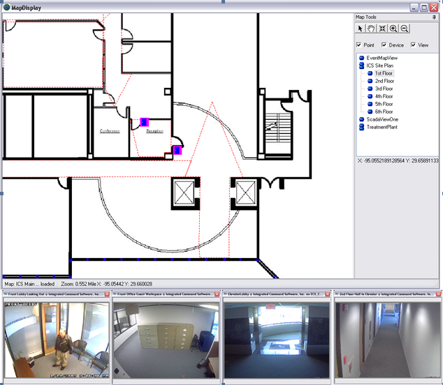
The window below provides an example of a geospatial map called by the occurrence of an event at a security point, in this case, the FRONT DOOR of ICS's offices. Note the door icon in the center of the screen. Selection of a row (by clicking on it) in the SCOREBOARD that relates to a map OBJECT defined in a map causes the map to display with that OBJECT centered in the window. This display is of the second floor of the facility. It is a zoomed-in and positioned view of second floor office space.
When the operator clicks on a map OBJECT (a Point or a Device), any default VIEWS are automatically displayed in predefined map windows, just like in the scoreboard.
If the device state of the OBJECT is available, the color representing that device state will be shown behind the icon defined for the OBJECT.
Right clicking on the OBJECT icon presents a variety of configurable options plus callup of the COMMANDS interface.
Simply clicking in the areas outlined with a faint dotted line will call up a video view associated with the area. Such a window will provide full video control as it is an ad-hoc QuickView window.
In the map list of floors, a floor may be selected by clicking on the desired floor in the exploration tree for the desired view. Geospatially, each floor map is stacked on top of each other and positioned correctly. Then selection of the floor presents the desired map to the operator.